
Loading live conditions...
Loading live conditions...
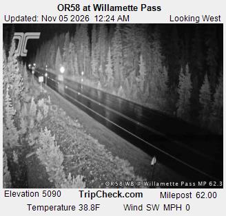
Willamette Pass is open, carry chains or traction tires, road surface: bare pavement, 39 degrees at the summit, updated NOV 4, 2026, 9:58 PM PST.
Last updated at: NOV 4, 2026, 9:58 PM PST · ODOT
 LIVE
 LIVE
 LIVE
 LIVE
Road surface at the pass: bare pavement. Temperature at the summit: 39°F. Weather: partly cloudy.
Road surface at the pass: bare pavement. Temperature at the summit: 39°F. Weather: partly cloudy.
Willamette Pass carries OR 58 over the Cascades at 5,128 feet, the highest crossing on this site, between Oakridge and Eugene on the west side and the US 97 junction near Chemult on the east. It is the Eugene route into Central Oregon and the freight alternative when the other passes are struggling.
The Willamette Pass ski area sits at the summit, and the east side drops past Odell Lake and Crescent Lake to the high desert. The live posting on this page is ODOT's report for the pass, with the summit cameras so you can see the road at 5,128 feet before you climb.
Planning around the weather? See the Willamette Pass weather forecast for the summit, hour by hour. Crossing the mountains the other way? Siskiyou Summit conditions on I-5 update from the same ODOT reports.
OR 58 is the freight minded crossing of the three Cascade passes on this site: it is the route trucks use when I-5 over Siskiyou Summit is in a conditional closure, and its grades, while real, are steadier than Santiam's two lane curves. The Salt Creek Falls tunnel segment on the west side is the tight point, and the long climb from Oakridge gains nearly 3,900 feet. Towing vehicles chain earlier in the posting ladder than solo cars. East of the summit the road drops past Odell Lake to the US 97 junction, and from there it is high desert running to Bend. In a storm, expect the truck traffic to find this pass, and expect company.
Chain up room on OR 58 is at the signed pullouts on both approaches and near the summit ski area turnoff. Oakridge is the last full services town on the west side and the place to make the call: if the summit cameras show snow sticking and the posting is up, put chains on in Oakridge where it is flat and lit rather than on the grade. East side, Chemult has fuel and a store but little else; the next real town is La Pine, 30 miles north on US 97. Willamette keeps winter longest of any pass here, and postings on OR 58 regularly outlast the storm that caused them by a day.
At 5,128 feet, Willamette Pass is the highest year round Cascade crossing in Oregon, about 300 feet above Santiam. On marginal days that difference is the whole forecast: rain at Santiam can be snow here, and snow here can be a chain posting while Santiam runs bare. Eugene drivers choose this pass because it is their direct line to Bend; Salem and Portland drivers should weigh the long swing south against Santiam's posting before rerouting. The Eugene to Bend page on this site tracks both summits in one place for exactly that decision.
Every posting change on this pass is logged in public: see the Willamette Pass status history.
Incoming storms, road conditions, and ski area news, straight to your inbox.